Trail Walking Reggio nell'Emilia - 2010-07-28 - 17h55m45 - Photo
 gico
gico

User

© OpenStreetMap contributors
Length
Length
4.2 km
Max alt
Max alt
102 m
Uphill gradient
Uphill gradient
28 m
Km-Effort
Km-Effort  
4.5 km
Min alt
Min alt
85 m
Downhill gradient
Downhill gradient
30 m
Boucle
Boucle
Yes
Creation date :
2014-12-10 00:00:00.0
Updated on :
2014-12-10 00:00:00.0

(0 Reviews)

Walking
Walking
--
Difficulty : Unknown

Scan this QR Code to open this trail in the SityTrail application

FREE GPS app for hiking

Logo SityTrail SityTrail

IGN / Geographical institutes

Download SityTrail from the App Store Download SityTrail from Google Play

Logo SityTrail SityTrail World

The world is yours!

Download SityTrail from the App Store Download SityTrail from Google Play Download SityTrail on Huawei AppGallery

About

Trail Walking of 4.2 km to be discovered at Emilia-Romagna, Reggio nell'Emilia, Reggio nell'Emilia. This trail is proposed by gico.

Elevation profile

Photos

Positioning

Country:
Italy
Region :
Emilia-Romagna
Department/Province :
Reggio nell'Emilia
Municipality :
Reggio nell'Emilia
Location:
Unknown
Start:(UTM)
626162 ; 4946165 (32T) N.

Trails nearby

Trail On foot Reggio nell'Emilia - Vasca Corbelli - Puianello - Montebello - Monte della Sella - Photo
On foot
PRO

On foot

Easy
Reggio nell'Emilia, Emilia-Romagna, Reggio nell'Emilia, Italy
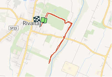
12.5 km | 17.8 km-effort
4h 2min
No
Trail On foot Quattro Castella - Montecavolo - Percorso 640B - Photo
On foot
PRO

On foot

Easy
Quattro Castella, Emilia-Romagna, Reggio nell'Emilia, Italy
5.2 km | 7.9 km-effort
1h 48min
No
Trail Walking Reggio nell'Emilia - 2010-08-19 - 16h41m44 - Photo
Walking
gico

Walking

Very easy
Reggio nell'Emilia, Emilia-Romagna, Reggio nell'Emilia, Italy
6.8 km | 7.5 km-effort
Unknown
Yes


Close
My subscriptions